

Updated Thursday April 16, 2026 at 10:00 a.m.
Scattered thunderstorms will continue into Friday. Large hail, damaging winds, and tornadoes are possible, according to the National Weather Service.
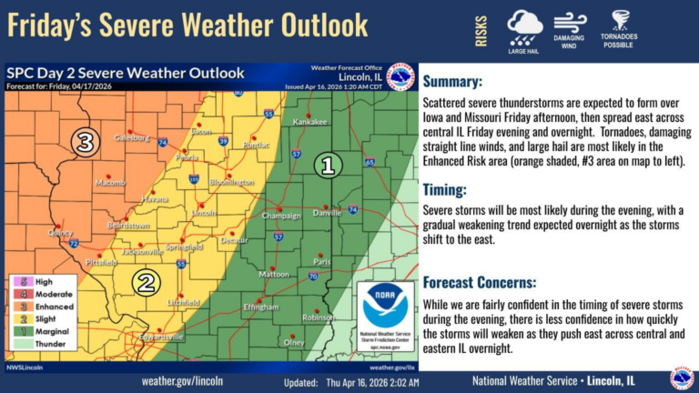
Scattered severe thunderstorms are expected to form over Iowa and Missouri Friday afternoon, then spread east across central IL Friday evening and overnight. Keep updated with later forecasts as this system develops! #ILwx pic.twitter.com/A2Xtwf4uS0
— NWS Lincoln IL (@NWSLincolnIL) April 16, 2026
Breezy and unseasonably warm weather will continue through Friday. A strong cold front moving into the area Friday night will bring scattered thunderstorms, some of which could be severe. Much cooler air will move in behind this front for the weekend. #ILwx pic.twitter.com/CZXBJ8yDll
— NWS Lincoln IL (@NWSLincolnIL) April 16, 2026
Updated Wednesday April 15, 2026 at 10:35 a.m.
Scattered showers and thunderstorms will continue today. Temperatures are expected to dip this weekend.
Scattered showers will continue northeast this morning, moving across areas west of I-55 over the next few hours. More development is expected later today. It will be a good day to have the umbrella handy. #ILwx pic.twitter.com/qloI193p7l
— NWS Lincoln IL (@NWSLincolnIL) April 15, 2026
Periods of storms will continue for the next few days. Some storms could be severe today. Breezy and warm weather will continue through Friday, before a strong cold front hits Friday night into Saturday morning. #ILwx pic.twitter.com/vdL0olAssE
— NWS Lincoln IL (@NWSLincolnIL) April 15, 2026
Scattered thunderstorms will affect the area this afternoon and evening. Some storms are forecast to become severe, with damaging winds, hail, and locally heavy rainfall. Be ready to take shelter indoors when storms approach. #ILwx pic.twitter.com/9WyJ2MRS3Q
— NWS Lincoln IL (@NWSLincolnIL) April 15, 2026
Updated Tuesday April 14, 2026 at 9:45 a.m.
Spring-like weather continues in Central Illinois with a few showers.
Breezy and warm weather will dominate the area for the remainder of the week. Occasional thunderstorms will affect the region, with a potential for severe storms today and Wednesday. #ILwx pic.twitter.com/7UwRpG7i6c
— NWS Lincoln IL (@NWSLincolnIL) April 14, 2026
Scattered storms will be around today and Wednesday, most numerous during the afternoon and evening hours. Some storms could become severe, with damaging winds and hail the primary risks. Seek sturdy shelter if a warning is issued for your area. #ILwx pic.twitter.com/PiCOnnaBiF
— NWS Lincoln IL (@NWSLincolnIL) April 14, 2026
Updated Monday April 13, 2026 at 10:30 a.m.
While the weather has warmed up, rain and storms are not going away anytime soon. The National Weather Service says severe storms are possible in parts of Central Illinois Tuesday and Wednesday.
Severe storms are possible for portions of central IL today through Wednesday. Be weather aware and have a severe weather plan in place ahead of time! #ILwx pic.twitter.com/aXmNy6QTTv
— NWS Lincoln IL (@NWSLincolnIL) April 13, 2026
Severe storms are possible for portions of central IL on Tuesday and Wednesday. Be weather aware and have a severe weather plan in place ahead of time! #ILwx pic.twitter.com/G3THdD4MPI
— NWS Lincoln IL (@NWSLincolnIL) April 13, 2026
Breezy and unseasonably warm weather will dominate the area this week. Thunderstorm chances will be frequent from Tuesday onward, with the best chance for widespread rainfall occurring on Wednesday. Some severe storms are possible Tuesday and Wednesday. #ILwx pic.twitter.com/SZsVudeoY4
— NWS Lincoln IL (@NWSLincolnIL) April 13, 2026