

Updated March 11, 2026 at 10:53 a.m.
Rain continued this morning in Central Illinois after a night of severe storms and hail in some parts of the state.
Updated March 11, 2026 2:10 a.m.
Storms finally reached the Champaign-Urbana area around 2:00 a.m. on Wednesday. By that time the National Weather Service in Central Illinois had canceled the Tornado Watch. Still, the rain was steady with some lightning and thunder.
Updated March 11, 2026 1:50 a.m.
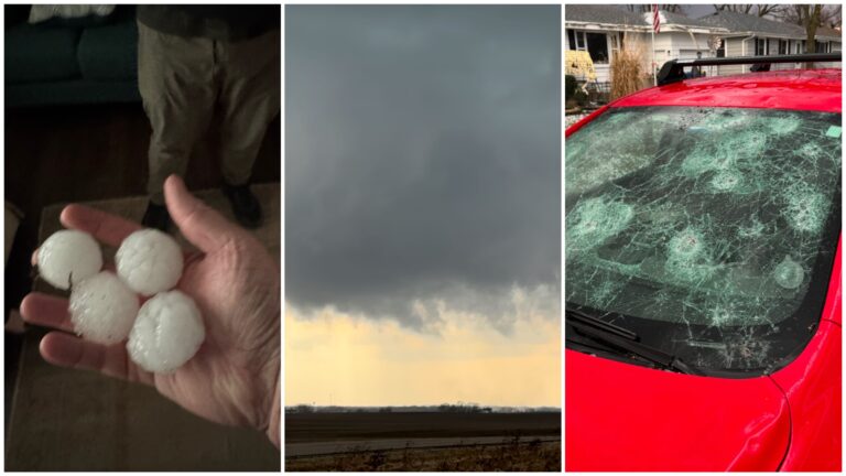
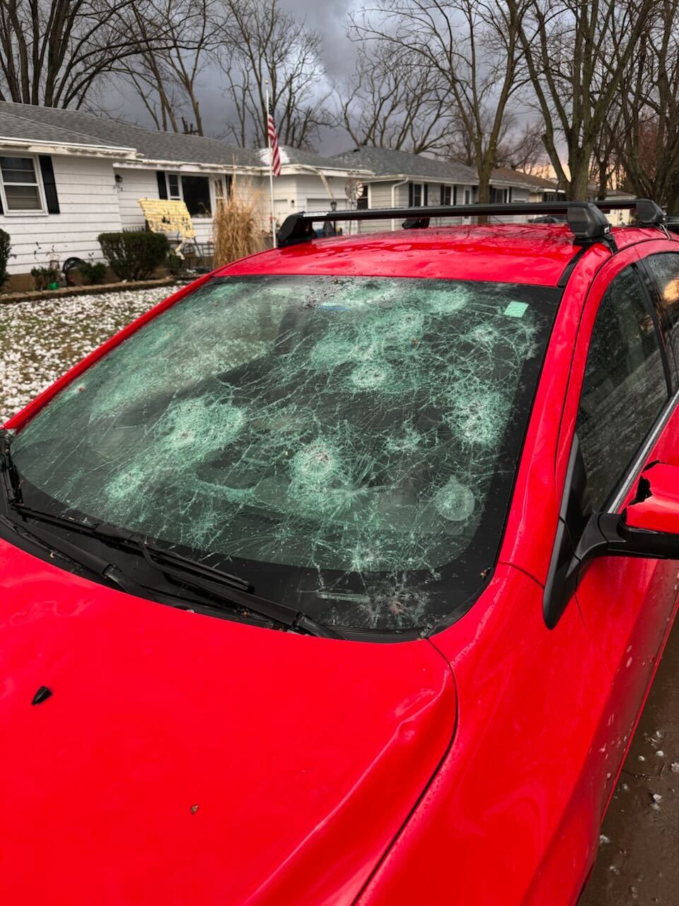
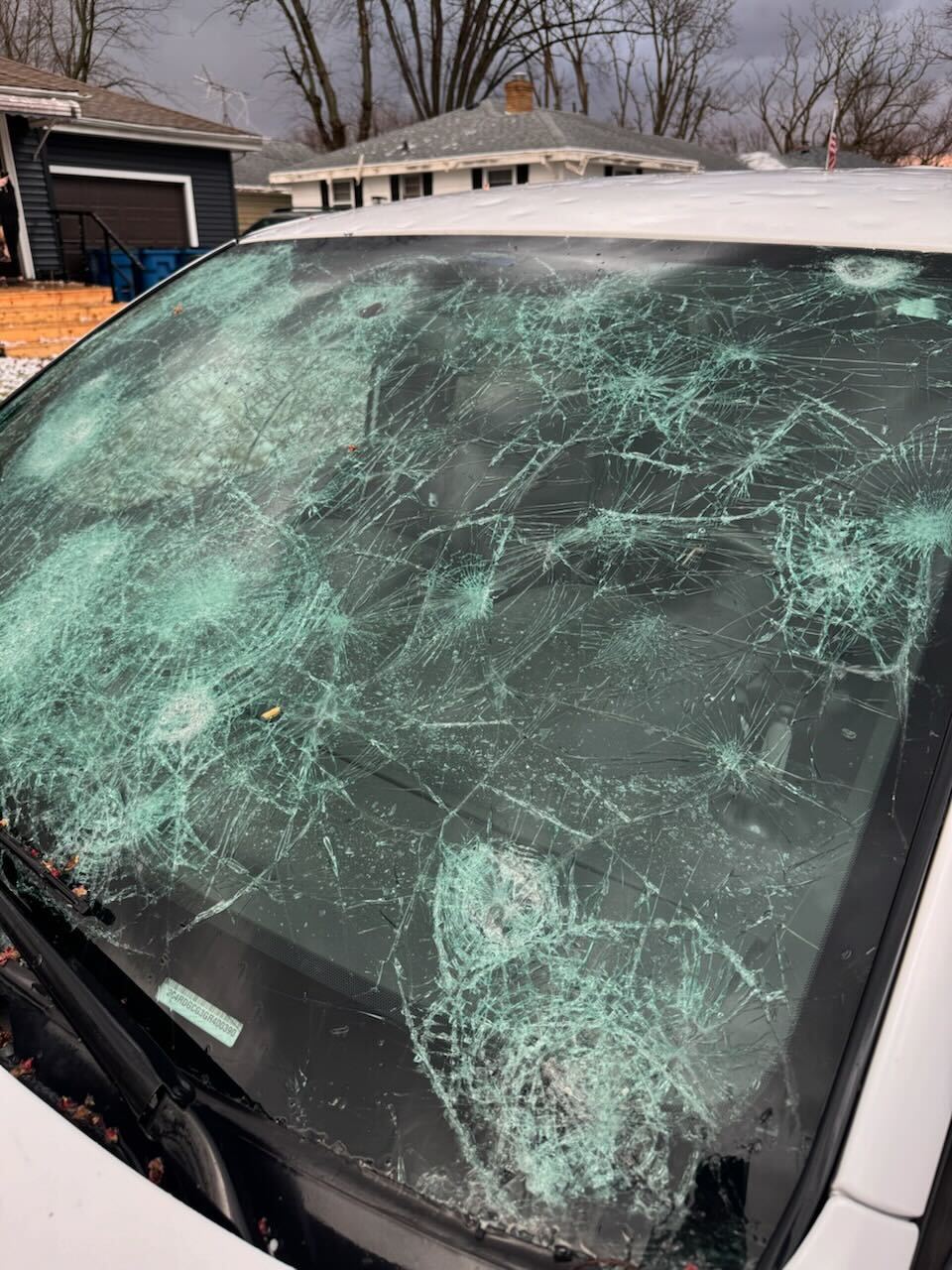
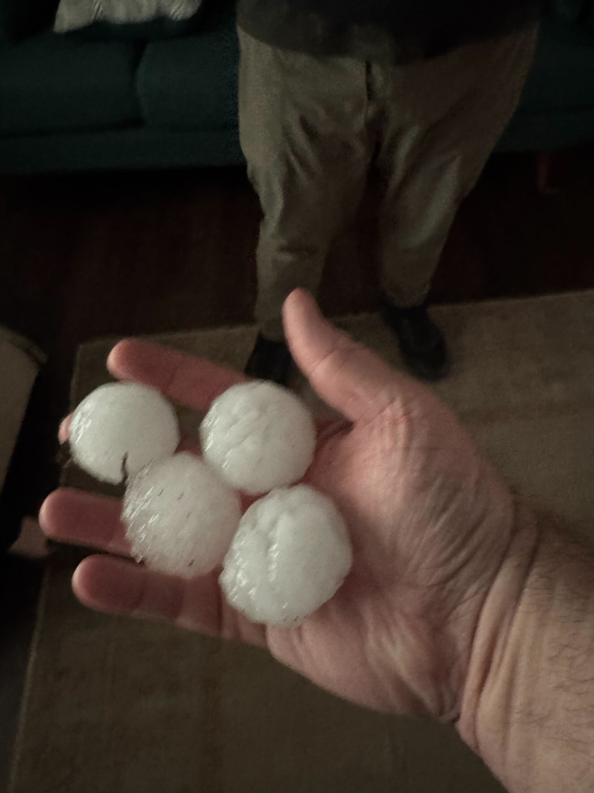
Major storms that whipped up tornadoes in parts of Illinois and Indiana on Tuesday leveled homes, downed trees and power lines, and overwhelmed a 911 center south of Chicago with emergency calls, according to officials.
“Please do not come here. Do not try to help right now,” Newton County Sheriff Shannon Cothran said in a video update in front of what looked to be a destroyed home in the small northwestern Indiana community of Lake Village.
Multiple homes in the community were destroyed in an apparent tornado, and Indiana State Police Cpl. Eric Rot said people had been injured. He wasn’t able to provide an exact number or their conditions.
Severe storms dumping rain and hail in parts of the Midwest were threatening to bring intense tornadoes, damaging winds and very large hail from the southern Plains to the southern Great Lakes, according to the National Weather Service. States from Oklahoma to Michigan were under tornado watches.
Several tornadoes formed across northeastern Illinois and northwestern Indiana, but the exact number won’t be available until officials conduct damage surveys, said Andrew Lyons, a meteorologist with the National Weather Service Storm Prediction Center.
He described this as a fairly typical early Spring strong storm system. It is expected to continue to move east across parts of the mid-Atlantic and East Coast Wednesday, likely bringing more severe weather, he said.
Illinois Gov. JB Pritzker said in a post on the social platform X that he’d been briefed on the storm and tornado damage.
“Keeping in our thoughts all Illinoisans impacted by the severe weather — we’ll be here to help them recover,” he said.
A tornado struck down near the Kankakee fairgrounds, about 57 miles (91.7 kilometers) south of Chicago, before traveling northeast into Aroma Park, where it caused extensive damage, according to the Kankakee County Sheriff’s Office. No injuries have been reported.
“I want to remind area residents to check on their neighbors and loved ones but to avoid unnecessary travel, if at all possible,” Kankakee County Sheriff Mike Downey said in a statement.
In video shared on social media, the twister is seen ripping across a field of farmland near an airport while vehicles lined the road.
More than 2 million Americans were at a moderate risk of severe weather in Illinois and Indiana. Nearly 22 million were at a slightly lesser risk in a zone that includes Chicago, Fort Worth, Texas, and Oklahoma City, Oklahoma. – Hallie Golden, Associated Press
Updated March 11, 2026 1:46 a.m.
The National Weather Service in Lincoln has issued a Tornado Watch that includes Champaign, DeWitt, Logan, Macon, Menard, Piatt, Sangamon and Vermilion Counties until Wednesday at 1:45 a.m. Meteorologists say the overnight storms will mainly pose a risk for damaging wind gusts but isolated tornadoes cannot be ruled out. Some storm cells will bring heavy rainfall resulting in flash flooding.
Updated March 10, 2026 7:26 p.m.
The National Weather Service in Chicago has issued a Tornado Watch for the northern edge of the WILL-AM listening area, including Ford, Iroquois, Kankee and McLean Counties. As of now, there are no weather issues in Champaign-Urbana so far, but large hail fell in Bradley Village, north of Kankakee. A tornado warning was issued in Kankakee County between 6:30-7:00 p.m. Earlier in the afternoon, IPM meteorologist Andrew Pritchard captured a brief tornado near Pontiac.
Updated March 10, 2026 at 4:30 p.m.
A Tornado Watch has been issued for parts of Illinois until 11 p.m.
A tornado watch has been issued for parts of Illinois, Indiana, Iowa and Missouri until 11 PM CDT pic.twitter.com/Uw9eDzeYvb
— NWS Lincoln IL (@NWSLincolnIL) March 10, 2026
While the timing of storm development remains somewhat uncertain, a Tornado Watch will be needed to cover this threat within the next 1-2 hours. Stay weather aware! #ILwx pic.twitter.com/pdRXBkHCOl
— NWS Lincoln IL (@NWSLincolnIL) March 10, 2026
Updated March 10, 2026 at 1:00 p.m.
Noon update from IPM meteorologist Andrew Pritchard: An outbreak of severe thunderstorms producing damaging hail and a few tornadoes is expected late this afternoon into the early overnight hours across portions of northern and central Illinois. Champaign-Urbana is not in the bullseye for today’s risk, but we are on the periphery and should keep a close eye on our west for any storms along the southern end of today’s outbreak that could clip our area. Prime time should be between 5:00 p.m. to midnight.
Updated March 10, 2026 at 8:30 a.m.
From IPM meteorologist Andrew Pritchard: a warm and windy spring day is expected across central Illinois, but scattered thunderstorms will develop ahead of an approaching storm system late this afternoon and evening, and there’s a chance a few storms could become severe across portions of northern and central Illinois into neighboring portions of Indiana. Large hail 2 inches in diameter and a few tornadoes are possible with the strongest storms, along with damaging wind gusts and locally heavy rainfall. The most likely time frame for severe storms in the immediate WILL severe weather coverage area is between 5:00 p.m. and midnight on Tuesday, though, rain and thunderstorms will continue into Wednesday morning.
From the National Weather Service Central Illinois: Severe thunderstorms are expected across central Illinois starting late Tuesday afternoon. The storms will continue late into the night. Meteorologists say damaging winds, large hail, and potentially strong tornadoes are possible. Heavy rain and localized flooding may also develop.
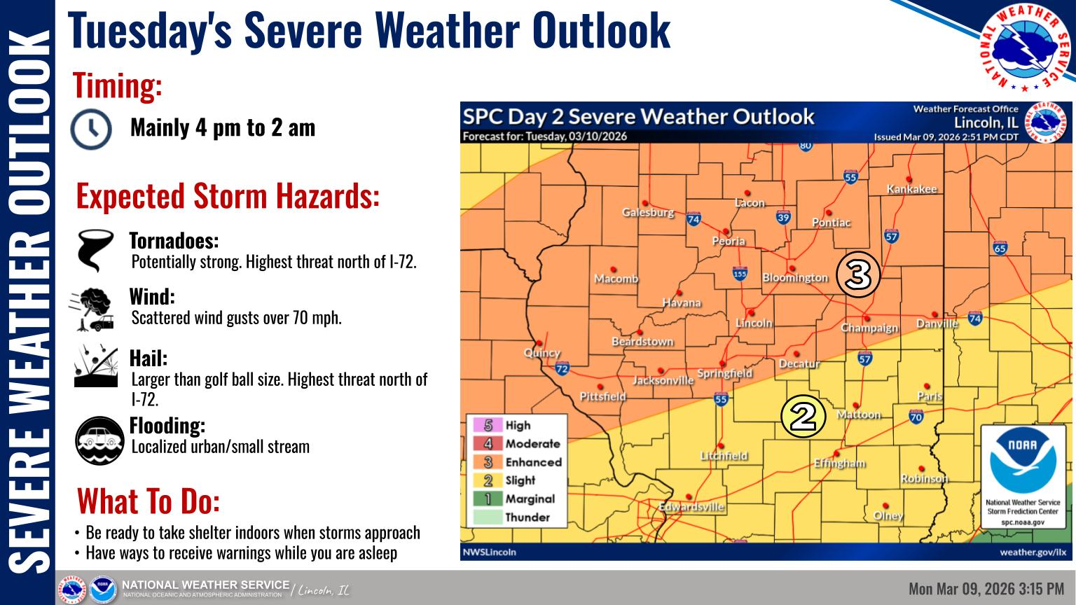
Updated March 9, 2026 at 12:00 p.m.
Despite lots of sunshine and warm temperatures on Monday, Central Illinoisans should brace themselves for severe storms on Tuesday.
The storms are expected to start in the late afternoon on Tuesday and continue through the evening and overnight, according to the National Weather Service.
IPM News meteorologist Andrew Pritchard says for now the risk of storms appears highest between 5 p.m. and 12 a.m. on Tuesday. The Storm Prediction Center has outlined an ‘Enhanced Risk’ level 3 out of 5 risk across portions of Champaign County/central Illinois, Pritchard says.
Strong winds, hail, a few tornadoes, heavy rain, and some flooding are all possible.
Severe thunderstorms are expected across central Illinois starting late Tuesday afternoon/evening, continuing overnight. All severe hazards will be possible: damaging wind, large hail, and a few tornadoes. Heavy rain & localized flooding may also develop. pic.twitter.com/AZw0nXxe7C
— NWS Lincoln IL (@NWSLincolnIL) March 9, 2026
Breezy and warm conditions will be in place to start the week. Severe storms are expected Tuesday afternoon and evening with the threat for storms continuing into Wednesday. pic.twitter.com/9xaANpvO34
— NWS Lincoln IL (@NWSLincolnIL) March 9, 2026