

Updated on Thursday, October 15 at 11:50 a.m. CT
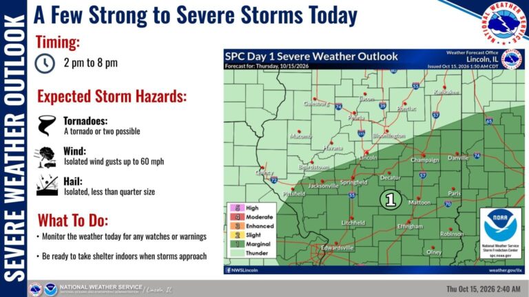
There is still a slight chance of severe storms today starting at 2 p.m. and continuing until 8 p.m.
Today’s severe weather outlook hasn’t changed much, with a level 1 risk from about Pittsfield to Rantoul southeastward. Isolated damaging winds are the main concern, though there is a low potential for a few tornadoes as well. The main time frame is from 2 pm to 8 pm. #ILwx https://t.co/FlT6rArey0
— NWS Lincoln IL (@NWSLincolnIL) October 15, 2026
After the rain passes, the weather will turn cooler going into the weekend.
Our first significant risk of frost for the season will be Friday night and Saturday night, when light winds and lows in the mid 30s promote the development of areas of frost. Plants may need to be covered if you wish to continue the growing season. #ILwx https://t.co/iCtvkxpP9a
— NWS Lincoln IL (@NWSLincolnIL) October 15, 2026
After the unseasonably warm weather this week, fall comes roaring back on Friday with wind gusts 25-35 mph and highs only in the 50s. A cold front will sweep across the area this evening. Periods of showers and thunderstorms are expected ahead of the front today. #ILwx https://t.co/0VxGf5leys
— NWS Lincoln IL (@NWSLincolnIL) October 15, 2026
Periodic chances for showers and storms continue through the end of the week with the highest probabilities being on Thursday. Cooler and drier weather is then expected heading into the weekend. #ILwx https://t.co/SF5QyHbqBj
— NWS Lincoln IL (@NWSLincolnIL) October 14, 2026
Updated on Wednesday, October 13 at 2:20 p.m. CT
Severe thunderstorms are possible Thursday in Central Illinois. Temperatures will dip to the 50’s towards the end of the week.
Periodic chances for showers and storms continue through the end of the week with the highest probabilities being on Thursday. Cooler and drier weather is then expected heading into the weekend. #ILwx https://t.co/SF5QyHbqBj
— NWS Lincoln IL (@NWSLincolnIL) October 14, 2026
A front will lift north on Thursday and bring the chance for strong to severe thunderstorms. Isolated damaging wind gusts will be the main concern, though a tornado or two cannot be ruled out in east central and southeast Illinois. #ILwx https://t.co/Ffp5iKMR5c
— NWS Lincoln IL (@NWSLincolnIL) October 14, 2026
As a cold front continues to push southward, a few strong to locally severe thunderstorms will remain a threat this morning south of I-70. A more widespread threat of strong/severe storms exists Thursday, as the front lifts back north. #ILwx https://t.co/LBg6rEoXt0
— NWS Lincoln IL (@NWSLincolnIL) October 14, 2026
Expect periodic showers/storms through Thursday night. However, dry weather will be more common this afternoon and evening. The end of the week will see much cooler weather, with our first chance of frost Friday night. #ILwx https://t.co/L3geG6fJyr
— NWS Lincoln IL (@NWSLincolnIL) October 14, 2026
Updated Tuesday, October 13 at 12 p.m. CT
Some of the past few days have felt more like summer than fall in Central and Southern Illinois.
That’s due to record heat with 90-degree highs. The last record high temperature for Champaign-Urbana for October 13 was 86 degrees in 1989, according to IPM News meteorologist Ed Kieser.
More record heat today, especially south of I-72/Danville, but highs in the 50s are likely by Friday. Expect periods of showers/storms from tonight into Thursday night. #ILwx https://t.co/ewvUkGhIf2
— NWS Lincoln IL (@NWSLincolnIL) October 13, 2026
RECORD HEAT before storms move in! Highs near 90° through Tuesday, followed by severe storm chances Tuesday evening and night (especially W of I-55) & rain through Thursday. A big cool-down follows this weekend with frost potential! Have multiple ways to get alerts. https://t.co/nLf0uzYt3U
— NWS Lincoln IL (@NWSLincolnIL) October 12, 2026
Record warmth will continue today with highs in the 80s to near 90F before a front brings multiple rounds of showers & storms tonight through Thursday night. Much cooler air arrives behind the front dropping highs into the 50s & 60s with frost potential Friday & Saturday nights. https://t.co/HCWAWRHGX7
— NWS Lincoln IL (@NWSLincolnIL) October 13, 2026
Springfield set a record high of 91 today beating the old record of 89 set in 1962. It is also the latest 90 degree day in the season. Peoria set a record high of 88 today beating the old record of 87 set in 2024. Lincoln tied a record high of 89 today which was set in 1962 #ILwx
— NWS Lincoln IL (@NWSLincolnIL) October 12, 2026
After the warm temperatures subside, showers are expected to start Tuesday night and continue through Thursday, according to the National Weather Service. There is also a low risk of severe storms.
An active weather pattern will bring a Marginal Risk for severe storms to portions of central IL Tuesday evening and night, primarily west of I-55. The main threats from these storms include damaging wind gusts up to 60 mph, hail to an inch in diameter, and locally heavy rain. https://t.co/Bx5EfLs7nt
— NWS Lincoln IL (@NWSLincolnIL) October 12, 2026
Severe storms are possible tonight, mainly west of I-57 in central IL! Primary threats include damaging winds, isolated large hail, and locally heavy rain. Highs near 90°F continue today before storms arrive. Have multiple ways to receive warnings! https://t.co/5xCDzxqjGO
— NWS Lincoln IL (@NWSLincolnIL) October 13, 2026