

Updated Tuesday May 19 at 2:50 p.m.
8:45 am — The latest SPC outlook continues to show a risk of severe weather later today, though in a smaller area of east central and southeast Illinois. #ILwx pic.twitter.com/5JeUWB4S7P
— NWS Lincoln IL (@NWSLincolnIL) May 19, 2026
Updated Tuesday May 19 at 10 a.m.
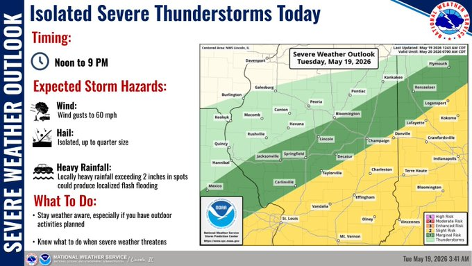
Showers and thunderstorms are not leaving Central Illinois just yet. The National Weather Service said the greatest risk of severe storms will be from noon until 9 p.m. Strong wind gusts, hail, and flash flooding are also predicted. Wednesday and Thursday are expected to be drier with sunshine.
Isolated severe thunderstorms possible today in central IL. The greatest threat for severe storms from noon to 9 pm from around I-72 southward. Threats include wind gusts over 60 mph, hail over 1 inch, and localized flash flooding from spots of over 2 inch rainfall. #ilwx pic.twitter.com/SbgwQnWads
— NWS Lincoln IL (@NWSLincolnIL) May 19, 2026
Additional showers and thunderstorms expected into this evening in central IL which could be severe. Showers will linger south of I-70 into Wednesday morning, then dry conditions are expected Wednesday through Thursday. Cooler through the work week. #ilwx pic.twitter.com/xYPuHnW9zS
— NWS Lincoln IL (@NWSLincolnIL) May 19, 2026
Updated Monday May 18 at 2:37 p.m.
The first round of severe storms is coming to an end, but there is still a chance of flooding this evening. The second round is expected to begin at 2 p.m. and continue until 8 p.m. on Tuesday. The National Weather Service is warning residents of hail, damaging winds, and a possible tornado or two.
Many parts of Central Illinois are under Flash Flood Warning until 6 p.m.
Round 1 of severe storms is winding down, but flooding will remain a threat through this evening. Round 2 will occur from 2 pm to 8 pm in the eastern half of IL. Hazards will be damaging winds, and large hail, with a brief tornado or two possible. #ilwx pic.twitter.com/RLptzDzoGh
— NWS Lincoln IL (@NWSLincolnIL) May 18, 2026
Updated Monday May 18 at 1:20 p.m.
A stalled line of storms could produce rainfall amounts over 3 inches in some locations of east-central and southeast Illinois. A few thunderstorms could produce rainfall rates over 1" per hour, increasing the chances of flooding, esp. in poor drainage and low lying areas. #ilwx pic.twitter.com/3HvBQKXFKz
— NWS Lincoln IL (@NWSLincolnIL) May 18, 2026
A line of strong thunderstorms will continue to shift eastward into southeast IL through mid-day, impacting areas south of I-70 for hours into the afternoon. Some of these storms could be severe, with isolated large hail to 1 inch. Flash flooding threat is increasing. #ilwx pic.twitter.com/LF7KCOZdoJ
— NWS Lincoln IL (@NWSLincolnIL) May 18, 2026
Updated Monday May 18 at 10:20 a.m.
The National Weather Service in Central Illinois has issued a Severe Thunderstorm Watch until 6 p.m. for the following counties:
CHAMPAIGN          CLARK               CLAY
COLES                COOK                CRAWFORD
CUMBERLAND           DOUGLAS             DUPAGE
EDGAR                EFFINGHAM           FORD
GRUNDY               IROQUOIS            JASPER
KANKAKEE             KENDALL             LAWRENCE
LIVINGSTON           MOULTRIE            PIATT
RICHLAND             SHELBY              VERMILION
WILL
Updated Sunday May 17 at 10:00 p.m.
From the National Weather Service in Central Illinois: Severe thunderstorms are possible both Monday and Tuesday. At this time, it appears that timing both days may be similar, as storms move into west-central Illinois early in the day, and migrate eastward through the day. Primary hazards both days will be damaging wind gusts of 60 miles per hour or greater and large hail 1 inch diameter or larger. Isolated tornadoes are also possible Monday afternoon in eastern Illinois, and over central and eastern Illinois on Tuesday afternoon/evening.