

Updated on Friday, April 16 at 11:30 p.m. CT:
IPM meteorologist Andrew Pritchard posted more video of a tornado he witnessed near Rockford earlier today.
Updated on Friday, April 16 at 11:00 p.m. CT:
The National Weather Service in Central Illinois has allowed the Tornado Watch to expire. The areas included were Champaign, Coles, Douglas, Moultrie, Piatt, and Vermilion County.
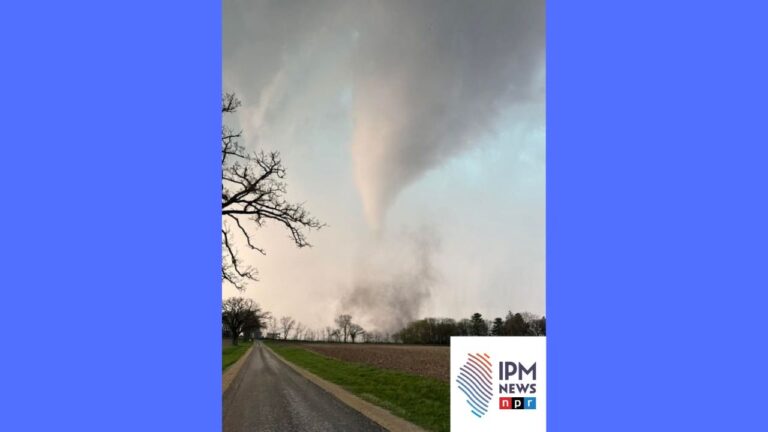
IPM meteorologist Andrew Pritchard reported the tornado threat is over for Champaign County. Earlier in the day, he captured pictures and video of tornadoes in northern Illinois.
Here is the IPM special report from 9:45-10:33 p.m.:
Updated on Friday, April 16 at 10:40 p.m. CT:
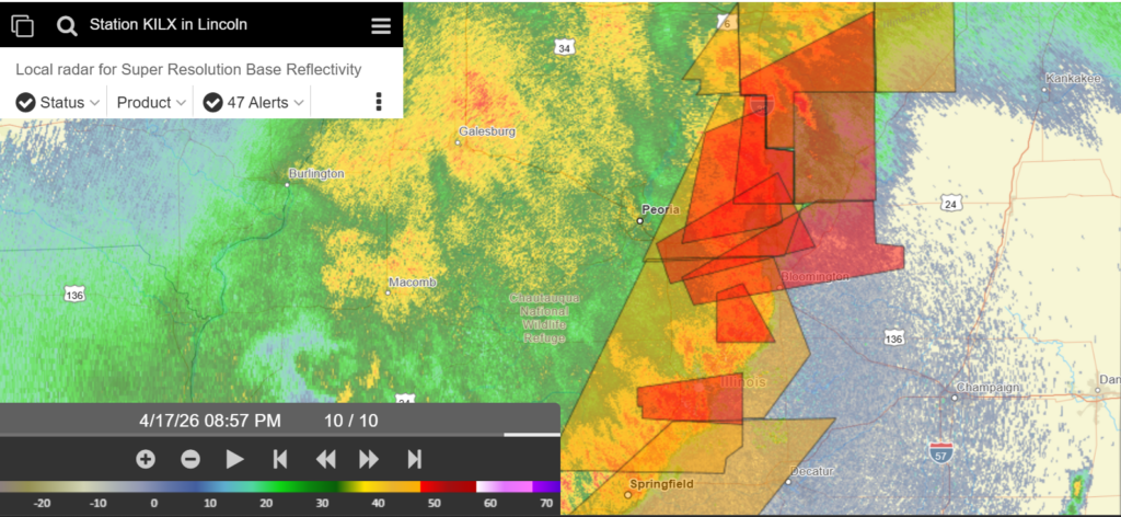
The National Weather Service in Central Illinois issued a Tornado Warning. IPM meteorologist Andrew Pritchard tracked the storm confirmed by weather spotters as it moved through Bondville, west of Champaign. The warning caused the University of Illinois Urbana Champaign to issue an Illini-Alert, encouraging students to take shelter indoors.
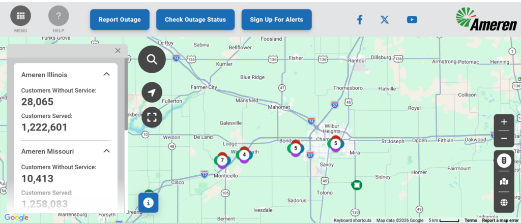
By 10:40 p.m., multiple power outages were reported west of Champaign.
Updated on Friday, April 16 at 9:37 p.m. CT:
From the National Weather Service in Central Illinois: A line of severe storms is moving through central IL with damaging straight-line winds and embedded tornadoes possible. Seek shelter in a sturdy structure when storms approach!
Updated on Friday, April 16 at 9:00 p.m. CT:
The National Weather Service has issued a Tornado Watch until 11:00 p.m. for the following counties: Champaign, Clark, Coles, Cumberland, Douglas, Edgar, Moultrie, Piatt and Vermilion. Within the last few hours, multiple tornado warnings have been issued throughout Central Illinois.
Updated on Friday, April 16 at 5:30 p.m. CT:
IPM meteorologist Andrew Pritchard said Central Illinois could see some storms, severe weather and possible tornadoes Friday night.
Original story:
From IPM meteorologist Andrew Pritchard: Today’s forecast is expected to be mostly sunny and windy with a chance of a thunderstorm late in the day and a high of 84 degrees. Tonight, thunderstorms are likely with a low of 52 degrees. A few storms could become severe with damaging winds and isolated tornadoes possible. The storms are ahead of a cold front. Tomorrow is expected to be cloudy and cooler with a high of 58 degrees.