

Updated August 13, 2026 at 1:27 p.m.
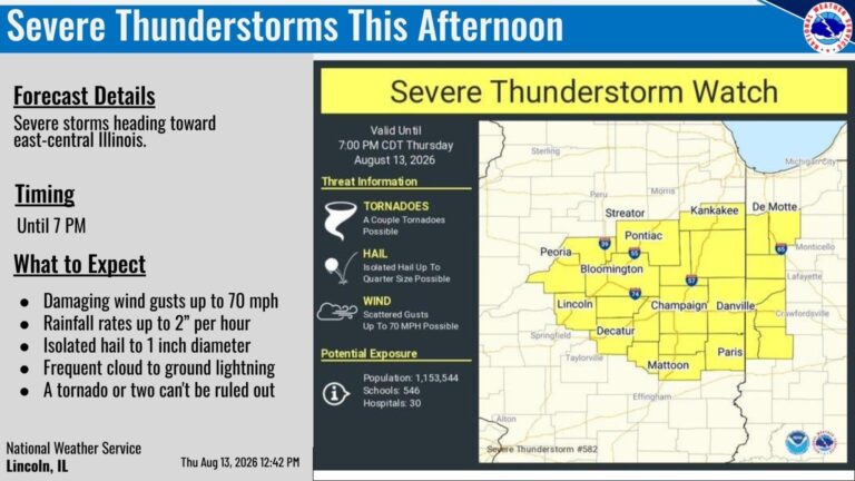
Central Illinois is under Severe Thunderstorm Watch until 7 p.m. Hail, damaging wind gusts, and heavy rainfall are expected.
Severe thunderstorm watch in effect for portions of central IL this afternoon. #ilwx pic.twitter.com/mtAM66i7MK
— NWS Lincoln IL (@NWSLincolnIL) August 13, 2026
Updated August 12, 2026 at 1:30 p.m.
12:05 pm — The morning storms have reduced the severe weather threat west of I-55, but a level 2 risk continues east of I-55 through the afternoon. Damaging winds are the main concern. #ILwx pic.twitter.com/9jgukchI8n
— NWS Lincoln IL (@NWSLincolnIL) August 12, 2026
Updated August 12, 2026 at 9:46 a.m.
The National Weather Service is predicting another round of strong storms to move into Central Illinois and continue until the afternoon today. However, IPM News meteorologist Andrew Pritchard says he is not “terribly concerned for now” noting that it looks like the strong storms are headed more towards the Chicago area as opposed to Central Illinois.
9:02 am — Strong storms continue to move through central Illinois. Wind gusts over 50 mph and intense lightning are expected with the strongest storms. #ILwx pic.twitter.com/Dm83JS81EW
— NWS Lincoln IL (@NWSLincolnIL) August 12, 2026
A thunderstorm complex is forecast to work through portions of central IL from mid morning through this afternoon. Damaging winds will be the primary hazard, with secondary hazards of large hail and a few tornadoes. Stay weather aware today! #ILwx pic.twitter.com/9BEOWxy3PE
— NWS Lincoln IL (@NWSLincolnIL) August 12, 2026
Updated August 11, 2026 at 4:00 p.m.
The Champaign-Urbana area is under Severe Thunderstorm Warning until 4 p.m.
Severe Thunderstorm Warning continues for Champaign IL, Urbana IL and Savoy IL until 4:00 PM CDT. This storm will contain wind gusts to 70 MPH! pic.twitter.com/hBMoiXFW4V
— NWS Lincoln IL (@NWSLincolnIL) August 11, 2026
Updated August 11, 2026 at 2:11 p.m.
In the latest update, the National Weather Service says strong storms are making their way to Champaign this afternoon. Chance of a tornado is minimal, but strong wind gusts and hail are expected.
1:55 pm — Strong to locally severe storms will move southeast into Champaign and Vermilion Counties through mid afternoon. Damaging winds and some hail are the main concerns. #ILwx pic.twitter.com/yGUP5daYrQ
— NWS Lincoln IL (@NWSLincolnIL) August 11, 2026
Updated August 11, 2026 at 9:45 a.m.
Champaign County and other parts of Central Illinois are under Severe Thunderstorm Watch until 2 p.m. today. IPM News meteorologist Andrew Pritchard says main concerns are strong wind gusts that could knock down power lines and trees. “Power outages are the primary concern where the strongest storms track,” he added in a Facebook post. Tornadoes are also possible.
In addition, the National Weather Service reports that extreme heat and humidity will continue throughout the week.
7:45 am — Severe Thunderstorm Watch has been issued until 2 pm for areas from about I-74 northward. Severe storms in Iowa will move across northern Illinois this morning, with potential for wind gusts >70 mph. #ILwx pic.twitter.com/VwoFiSuIDh
— NWS Lincoln IL (@NWSLincolnIL) August 11, 2026
Seasonally hot and humid weather continues through midweek with peak heat indices between 100-105° each afternoon. Protect yourself from the heat by staying hydrated and limiting time outdoors. #ILwx pic.twitter.com/LQuJraxmYj
— NWS Lincoln IL (@NWSLincolnIL) August 11, 2026
Updated August 10, 2026 at 3:12 p.m.
Central Illinois residents should be prepared for the risk of severe storms starting later this evening and lasting until Tuesday. Flooding and strong winds are possible, according to the National Weather Service. The beginning of the week is also expected to be hot and humid with temperatures as high as 99 degrees.
Widespread heat index around 105 degrees is expected, though this will be dependent on thunderstorms and associated cloud cover. Outdoor activities would be best done in the early morning or the evening hours. #ILwx pic.twitter.com/tI5LSiIKaH
— NWS Lincoln IL (@NWSLincolnIL) August 10, 2026
The midday outlooks from @NWSSPC have introduced a level 3 severe weather risk for Tuesday over much of northern IL. There is some question as to how far south these initial storms make it (I-74 corridor is plausible), though additional PM storms are likely in central IL. #ILwx pic.twitter.com/1ieBmLYPhH
— NWS Lincoln IL (@NWSLincolnIL) August 10, 2026
Seasonally hot and humid weather sticks around through midweek with peak heat indices between 100-105° each afternoon. Protect yourself from the heat by staying hydrated and limiting time outdoors. #ILwx pic.twitter.com/6RqggVZiHl
— NWS Lincoln IL (@NWSLincolnIL) August 10, 2026
Several rounds of storms will move through northern and central IL this week, posing a threat for severe weather. Primary hazards within any storms will be damaging winds gusts and heavy rain, though isolated large hail and a few tornadoes cannot be ruled out. #ILwx pic.twitter.com/aT2HMSXiR0
— NWS Lincoln IL (@NWSLincolnIL) August 10, 2026