

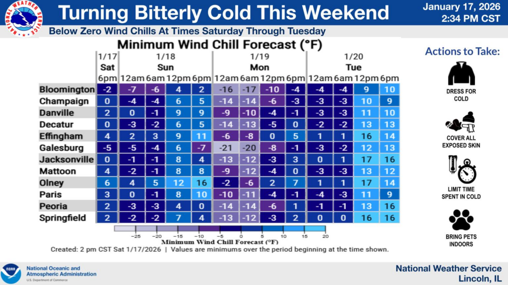
Updated Monday at 10:05 a.m.
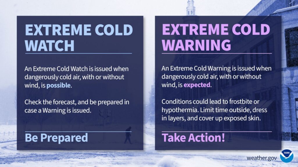
A Cold Weather Advisory continues until noon Monday, according to the National Weather Service.
Here is a look at the cold weather headlines in effect this morning and tonight. #ILwx pic.twitter.com/YJMhwgy1IN
— NWS Lincoln IL (@NWSLincolnIL) January 26, 2026
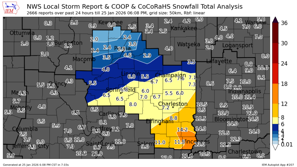
NWS reports the following amounts of snowfall:
- 4.5 inches in Paxton and Mahomet
- 5 inches in Rantoul
- 6.5 inches in Urbana
- 7 inches in Danville and Mattoon
- 14 inches in Village of Oblong in Crawford County
Updated Sunday at 7:30 p.m.
According to National Weather Service reports, here are some of the snow depth reports. Click here for the full report:
- Chicago O’Hare Airport: 3.5″
- Mahomet and Paxton: 4.5″
- Rantoul: 5″
- Urbana: 6.5″
- Danville and Mattoon: 7″
- Collinsville (Metro East): 8.5″
- Carbondale: 9″
- Near Chicago’s Navy Pier: 10.5″
- Village of Oblong (Crawford County): 14.5″
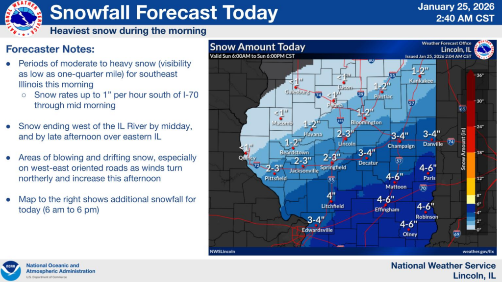
Updated Sunday at 6:30 p.m.
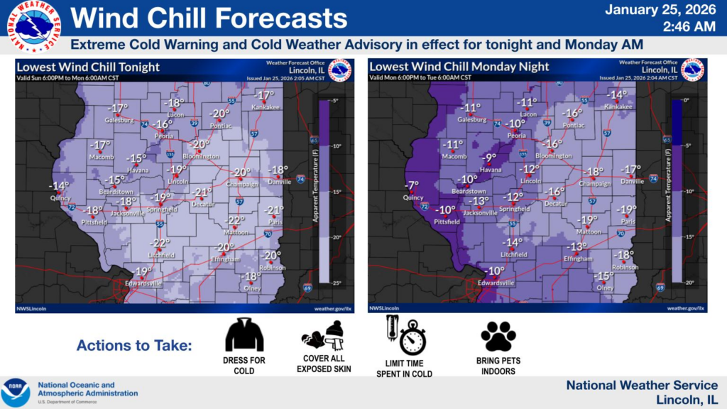
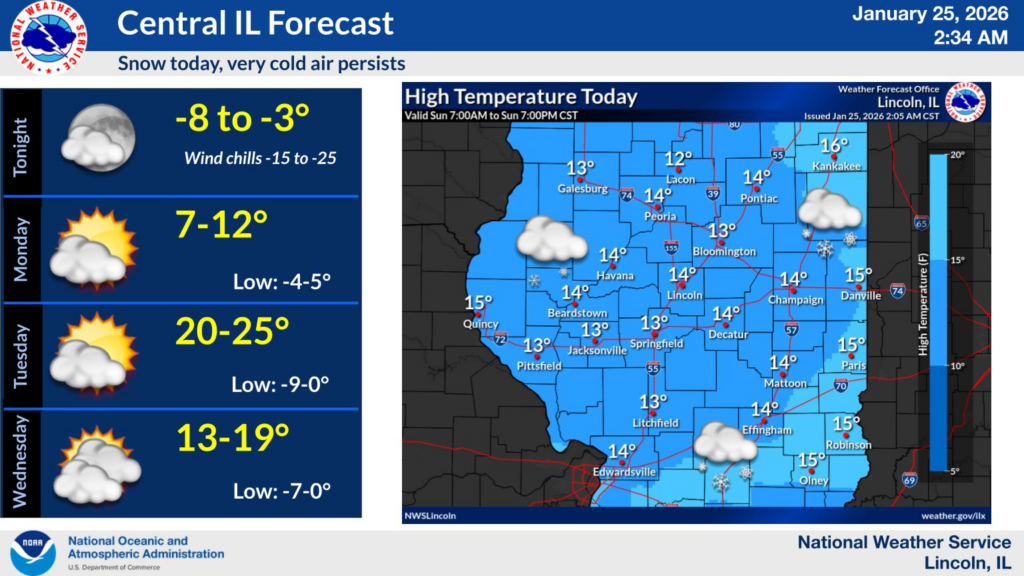
The National Weather Service in Central Illinois says the snowstorm that brought several inches of snow over the past 48 hours is over. The Winter Storm Warning has expired. Dangerously cold temperatures returned Sunday night, prompting a Cold Weather Advisory.
Here are snow total reports from this weekend:
Updated Sunday at 11:00 a.m.
From IPM meteorologist Andrew Pritchard:
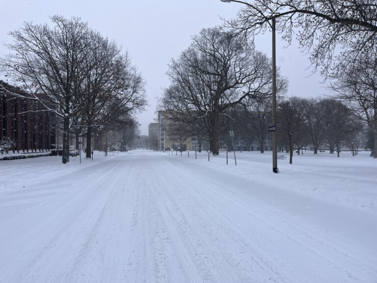
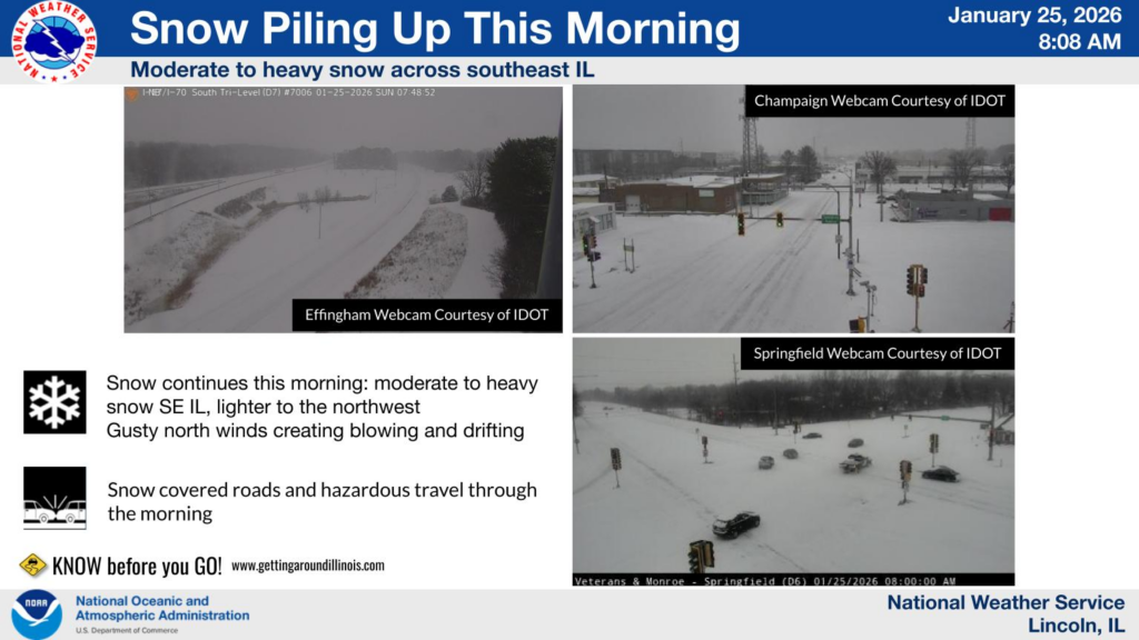
Light to moderate snowfall will continue for much of the day, tapering off by this evening. Between four to six inches of snow has already fallen across Champaign County, with another two to four inches possible today for a storm total of up to 10 inches in some areas. Blustery winds gusting to 25 miles per hour will lead to blowing snow and hazardous travel in rural and open areas through Monday. Dangerously cold temperatures, including sub-zero low temperatures, are expected through the entire week ahead.
Updated Saturday at 8:30 a.m.
Click here for an in-depth forecast analysis from Andrew.
Updated Friday at 5:30 p.m.
Temperature will continue to drop below zero overnight. Snowfall is expected start Saturday morning.
Expect another night of double-digit below zero wind chills tonight. Snow begins to move in Saturday afternoon, with snow likely to continue into early Sunday evening. #ILwx pic.twitter.com/ZhLdPg850W
— NWS Lincoln IL (@NWSLincolnIL) January 23, 2026
2:45 pm — Highlights for this forecast cycle:
— NWS Lincoln IL (@NWSLincolnIL) January 23, 2026
➡️ 5-10" the most likely outcome near/south of I-70; 10-30% chance of a foot of snow.
➡️ Two waves of snow, with a lull expected Saturday evening. Bulk of the snow accumulations between midnight-noon Sunday. #ILwx pic.twitter.com/Sj6dVy7e36
Updated Friday at 8:00 a.m.
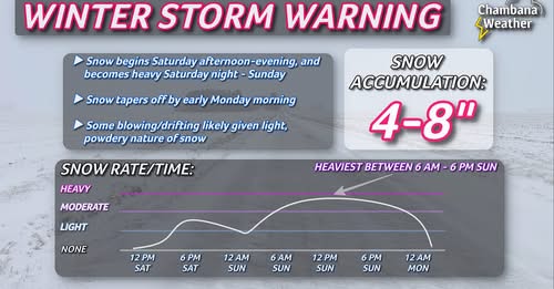
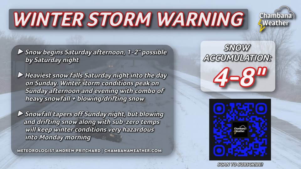
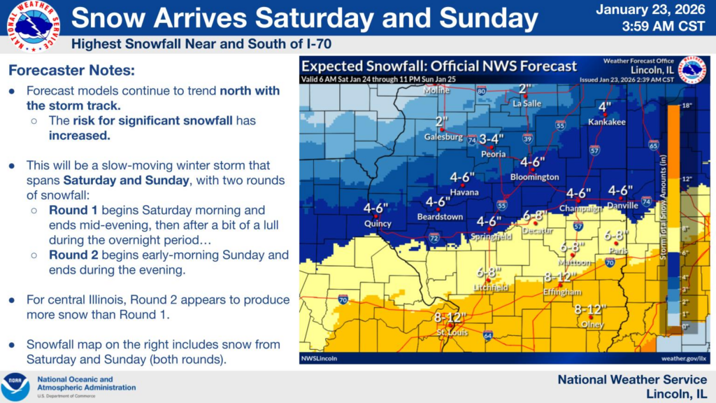
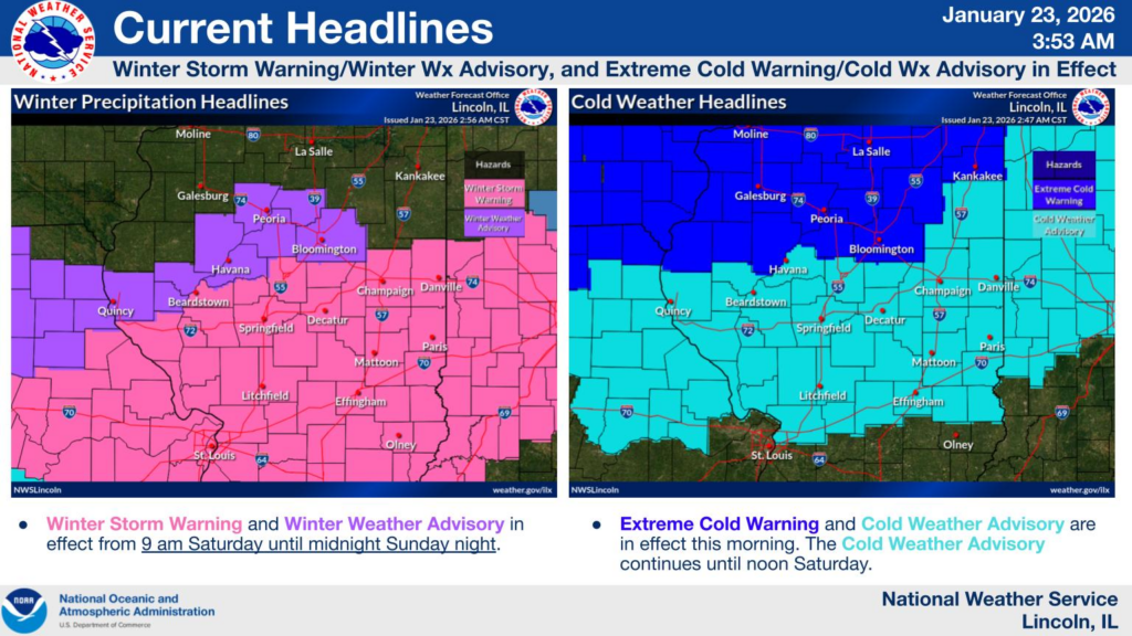
From IPM meteorologist Andrew Pritchard: A WINTER STORM WARNING goes into effect Saturday afternoon and lasts through the day Sunday for Champaign County and surrounding portions of east-central Illinois. Much of the day Saturday may be quiet and snow-free, with snow beginning to fall Saturday afternoon and evening. Snow will eventually become heavy during the day on Sunday, tapering off by early Monday morning. 4-8″ of total snowfall is expected in and near Champaign County. Northeast winds 10-15, gusting 20-25 mph at times may lead to blowing & drifting snow, especially in rural and open areas given the light and powdery nature of the snow.
Updated Thursday at 3:00 p.m.
A Winter Storm Watch will be in effect for much of Central Illinois starting midday Saturday. A Cold Weather Advisory could go into effect Thursday night into Friday morning and then continue through midday Saturday.
⚠️ The probability of accumulating snow this weekend has increased, and a Winter Storm Watch is in effect from I-72/Vermilion County and southward. Two rounds of snow are expected, one mainly Sat afternoon, and one mainly during the day Sun. Expect regional travel impacts. #ILwx pic.twitter.com/sNxFcKnJM9
— NWS Lincoln IL (@NWSLincolnIL) January 22, 2026
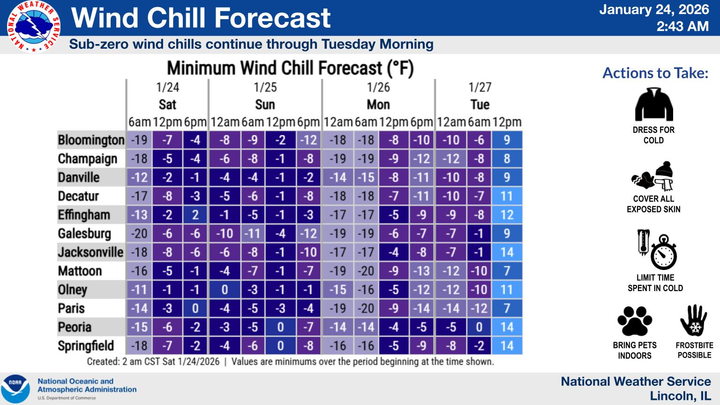
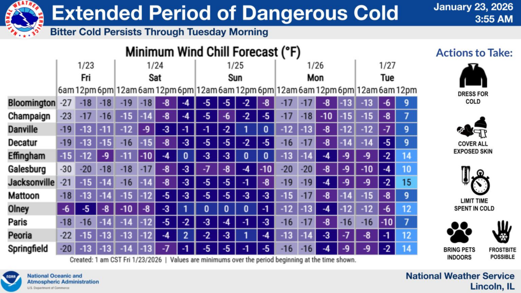
Bitter, Arctic air arrives tonight, along with breezy northerly winds, resulting in wind chill values of -20° to -30° north of I-72 Fri AM, and -5° to -20° south of I-72. Extreme Cold Warnings/Cold Weather Advisories are in effect. Frostbite can occur in under 30 minutes! #ILwx pic.twitter.com/qoKYJkMRxu
— NWS Lincoln IL (@NWSLincolnIL) January 22, 2026
Updated Thursday at 9:54 a.m.
Temperatures are expected to drop Friday to as low as -20 to -30, according to the National Weather Service. The first round of snowfall is expected to begin mid-day Saturday and again mid-morning Sunday. Forecasters predict snowfall to exceed four inches.
Significant snowfall is targeting portions of southern and central Illinois this weekend (Jan 24-25). Here are some of our forecaster notes, as well as the latest probability of exceeding 4" of snow. pic.twitter.com/ZIxf8jLlyP
— NWS Lincoln IL (@NWSLincolnIL) January 22, 2026
Life-threatening cold grips the region Friday & Saturday (Jan 23-24) with wind chill values ranging 20-30 degrees below zero on Friday, and 10-20 degrees below zero on Saturday. #ILwx pic.twitter.com/soSVheVpC0
— NWS Lincoln IL (@NWSLincolnIL) January 22, 2026
An arctic front will push across central IL tonight with wind chills of -5 to -30. The cold will persist through the weekend. A winter storm will impact the region this weekend with portions of central IL getting accumulating snow. The highest amounts are expected south of I-70. pic.twitter.com/VqzDsYlcE6
— NWS Lincoln IL (@NWSLincolnIL) January 22, 2026
Updated Tuesday at 8:00 a.m.:
From IPM meteorologist Andrew Pritchard: For today, partly cloudy with a high of 27 degrees. Southwest wind 5 to 15 mph… Tonight, cloudy with a low of 23 degrees. South wind 10 to 20 mph… Tomorrow, mostly sunny with a high of 37 degrees. West wind 10 to 15 mph… Tomorrow night, partly cloudy with a low of 19 degrees. Northwest wind 10 to 15 mph… And for Thursday, mostly sunny with a high of 28 degrees. West wind 10 to 15 mph.
The National Weather Service in Central Illinois is forecasting another round of dangerous, cold temperatures by week’s end.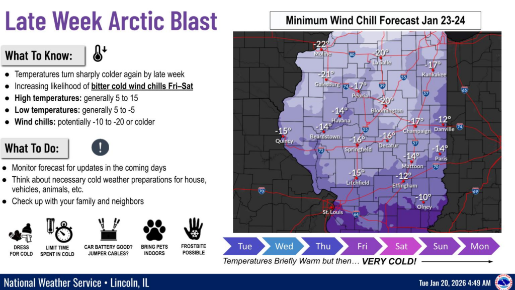
Updated Monday at 9:00 a.m.:
From the National Weather Service in Central Illinois:
- A Cold Weather Advisory remains in effect through midday for wind chill values of 10 to 20 degrees below zero. The threat of cold to occasionally very cold weather will return later this week.
- Near daily chances (10-30%) for light snow exist throughout this week and upcoming weekend, but with little or no new accumulation.
Updated Monday at 2:45 a.m.:
From the National Weather Service in Central Illinois: Temps will fall into the single digits across most of central Illinois early on this Monday morning. Wind Chill Values of -5 to -20 will be common. A Cold Weather Advisory remains in effect through Noon.
Updated Sunday at 11:00 a.m.:
From the National Weather Service in Central Illinois: Temps will fall into the single digits across most of central Illinois tonight into Monday morning. Wind chill values of -5 to -20 will be common. A Cold Weather Advisory has been issued for area along and north of I-70. It is in effect until Monday at noon CT.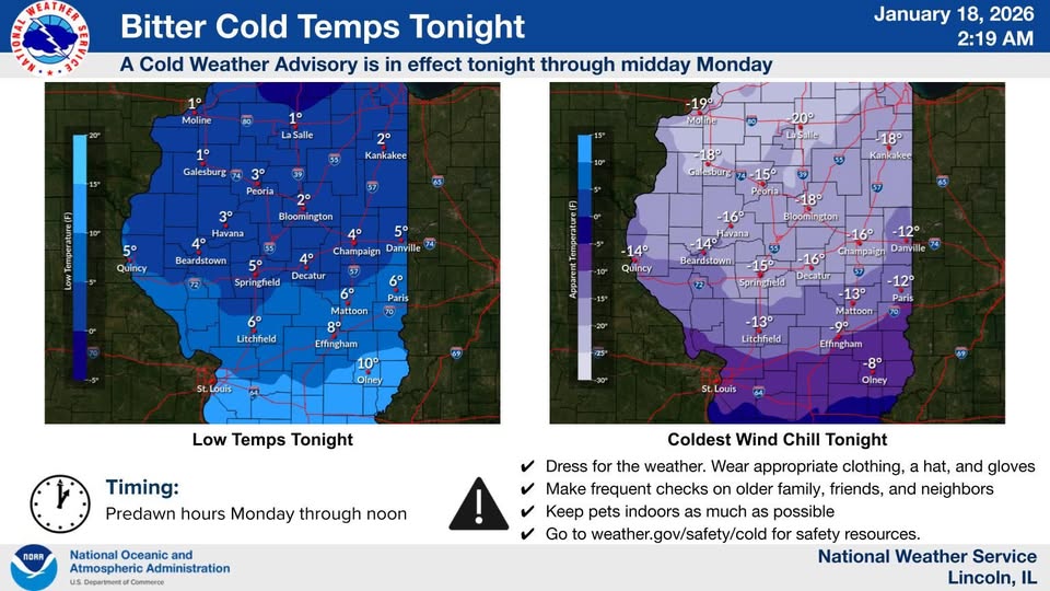
Updated Saturday at 6:30 p.m.:
From the National Weather Service in Central Illinois: much colder air arrives over the weekend and continues into early next week. Sunday night will be the coldest with lows in the single digits and wind chill values as cold as 20-25 below in spots.
Here are a list of warming shelters in Champaign County:
-
Strides Low Barrier Shelter (City of Champaign Township), 70 E Washington, Champaign
-
Winter Overflow Emergency Shelter for Families with Minor Children, 307 South Neil Street, Champaign
- Crisis Nursery, 1309 West Hill Street, Urbana
- C-U at Home, 309 S. Neil St. Champaign
Updated Saturday at 4:30 a.m.:
Meteorologists at the National Weather Service in Central Illinois are forecasting dangerously cold temperatures, with lows in the single digits and sub-zero wind chills each morning from Sunday through Tuesday.
Updated Friday at noon:
While snow flurries continue to fall off and on across central Illinois, resulting in some minor accumulations, the bigger story becomes an incoming shot of cold air this weekend into early next week.The first cold blast arrives on Saturday, sending overnight lows and morning temperatures on Sunday into the single digits, with wind chills as cold as 5 below zero. A reinforcing shot of cold air will have our high temperatures in the teens on Monday, with overnight lows near zero, and wind chills as cold as 5 below zero. A reinforcing shot of cold air will have our high temperatures in the teens on Monday, with overnight lows near zero, and wind chills approaching 10 below zero at times.We’ll see temperatures moderate midweek, but more cold is likely on the way in the last week of January.
Updated Thursday at 10:00 p.m.
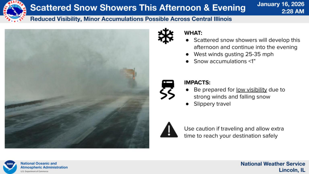
From the National Weather Service in Central Illinois: If you plan to travel tomorrow afternoon or evening, allow extra time as scattered moderate to heavy snow showers will be around. Accompanied by gusty winds, these could result in sudden, sharp visibility reductions, so be prepared to slow down should you encounter one.
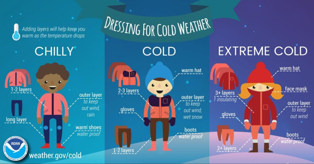
From Naitonal Weather Service in Central Illinois: Expect bitter cold temperatures to arrive this weekend, with wind chills likely to drop below zero at times Saturday through early next week.
Updated Thursday at 12:00 p.m.
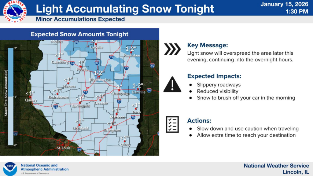
Snowfall is expected begin in the evening.
Snow looks to begin around 6 PM northwest of the Illinois River and spread southeastward past I-70 by 9 PM. Snow should taper off to flurries by Friday morning. Amounts should be generally near or under an inch. pic.twitter.com/pULzlQaBAZ
— NWS Lincoln IL (@NWSLincolnIL) January 15, 2026
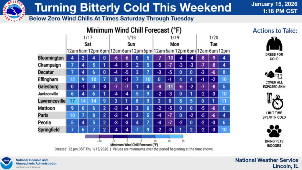
Expect bitter cold starting this weekend, with wind chills likely to drop below zero at times for much central IL from Saturday into early next week. This will bring a risk of hypothermia and frostbite with extended exposure. #ilwx pic.twitter.com/cEmCBeuvdj
— NWS Lincoln IL (@NWSLincolnIL) January 15, 2026
Light snow accumulations possible again in central IL Friday night. Accumulations will likely be under an inch (only around a 10 percent chance of exceeding an inch). Despite light amounts, areas of slippery road conditions could result as temperatures plummet. #ilwx pic.twitter.com/LTe5qobEeQ
— NWS Lincoln IL (@NWSLincolnIL) January 15, 2026
Updated Wednesday at 4:00 p.m.
The bitter cold is making its way back to Central Illinois this weekend.
Cold weather arrives today in central IL, then even colder by the weekend. Snow likely Thursday night, and possible again Friday night. #ilwx pic.twitter.com/udnsQXrFL4
— NWS Lincoln IL (@NWSLincolnIL) January 14, 2026
Light snow likely Thursday night in central and southeast IL. Accumulations could exceed an inch, especially northeast of a Galesburg to Springfield to Mattoon line. #ILwx pic.twitter.com/dkzPqbE9Px
— NWS Lincoln IL (@NWSLincolnIL) January 14, 2026