

Updated Tuesday April 7, 2026 at 10:35 a.m.
Light rain and snow through the morning today for portions of west-central into southeast Illinois. Little or no accumulation. Winds breezy Wednesday and Thursday, with chances for showers and thunderstorms developing Thursday and continuing into the weekend. #lwx pic.twitter.com/OPDsfgpb64
— NWS Lincoln IL (@NWSLincolnIL) April 7, 2026
Updated Monday April 6 at 11:00 a.m.
The National Weather Service is predicting freezing temperatures overnight. Temperatures are expected to warm up again by Wednesday with a chance of rain on Friday.
Rain and snow will spread into west central IL late this evening and could extend into southeast IL by Tuesday morning. Accumulations under an inch on grassy surfaces could take place from around Springfield westward by Tuesday morning. Cool through Tuesday then warmer. #ilwx pic.twitter.com/T2xNKE9Y30
— NWS Lincoln IL (@NWSLincolnIL) April 6, 2026
Freezing temperatures late tonight into Tuesday morning near and north of I-74. To the south, temperatures likely near to slightly above freezing. Where freezing temperatures are possible (north of I-70) you can move vulnerable plants indoors or cover to protect to protect. #ilwx pic.twitter.com/n4XsIbRBIr
— NWS Lincoln IL (@NWSLincolnIL) April 6, 2026
Updated Saturday April 4 at 8:55 p.m.
There is a medium-high (40-80%) chance for sub-freezing temperatures Monday night into Tuesday morning across much of the region. Here is a visualization of the latest probabilities for select cities across central Illinois. #ILwx pic.twitter.com/N8AvFMYfND
— NWS Lincoln IL (@NWSLincolnIL) April 4, 2026
A period of cooler and drier weather will stretch into the middle of next week. This period will be highlighted by frost & freeze potential late Monday night into Tuesday. #ILwx pic.twitter.com/owbiKueaQ0
— NWS Lincoln IL (@NWSLincolnIL) April 4, 2026
Confirmed Tornado: 4/3/2026
— NWS Lincoln IL (@NWSLincolnIL) April 4, 2026
EFU, 3 SW Hopedale, IL (Tazewell Co)
Thank you spotters & chasers, as well as our broadcast media & EM partners. Y'all shared some great shots yesterday, which help more than you know.https://t.co/bbINmy8HTp#ILwx pic.twitter.com/Sm6ZwapRfA
Updated Saturday at 12:30 a.m.
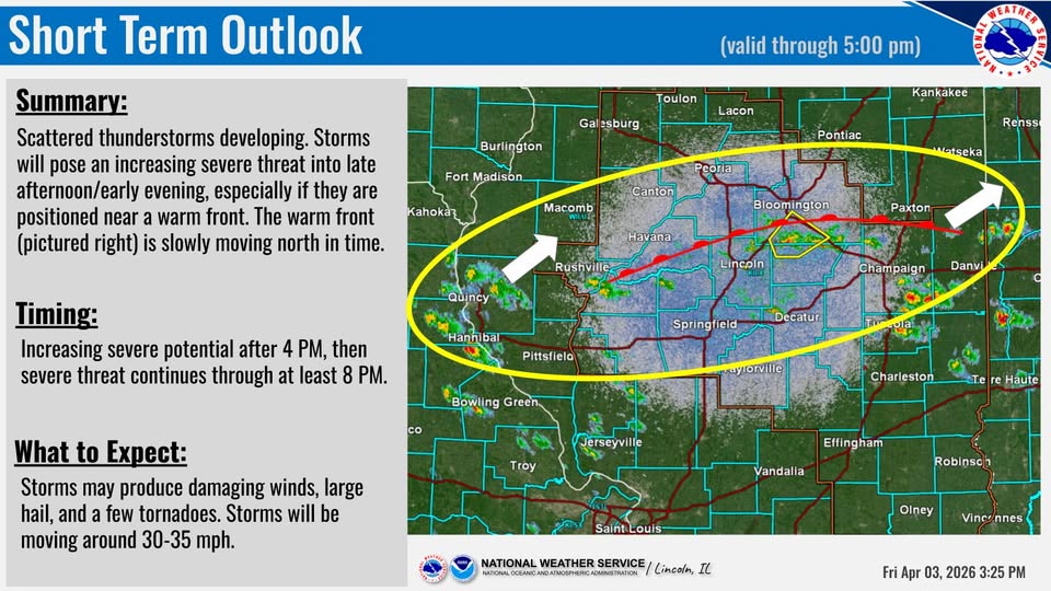
From the National Weather Service in Central Illinois: additional showers and thunderstorms along a cold front will move east through central IL after midnight into mid morning tomorrow. These could also be strong to severe.
From the National Weather Service in Central Illinois: A tornado watch is in effect for portions of central Illinois until Friday at 10:00 p.m. Scattered thunderstorms will be capable of producing large hail, damaging winds, and a few tornadoes.
Updated Wednesday April 1, 2026 at 10:00 a.m.
After a night of thunderstorms, the National Weather Service predicts more today, Friday, and Saturday. Drier weather is expected to return on Sunday.
Severe thunderstorms are possible both Thursday and Friday. Stay weather aware the next few days and check back for later updates. #ILwx pic.twitter.com/1JDNSxEyKX
— NWS Lincoln IL (@NWSLincolnIL) April 1, 2026
There is a 40-60% chance south winds will gust over 45 mph Thursday. This could cause difficult travel for high profile vehicles and blow around any unsecured, lightweight objects. #ILwx pic.twitter.com/fm55sXZVKf
— NWS Lincoln IL (@NWSLincolnIL) April 1, 2026
Periods of showers and thunderstorms are expected through Saturday with cooler and drier weather making a return by Sunday. pic.twitter.com/TEwPSOhvqF
— NWS Lincoln IL (@NWSLincolnIL) April 1, 2026
Updated Tuesday March 31 at 6:00 p.m.
From the National Weather Service Central Illinois: The primary threats are locally damaging wind gusts over 60 mph and large hail that could exceed golf ball size in a few storms, mainly prior to 10 PM. A tornado or two are possible as well.
Updated Tuesday March 31 at 11:20 a.m.
Clusters of strong to severe thunderstorms will impact locations east of highway 51 to near I-57, north of I-70 through noon. Some of the cells will be capable of quarter to ping pong sized hail and gusty winds over 50 mph. #ILwx pic.twitter.com/VOqGjUYw6s
— NWS Lincoln IL (@NWSLincolnIL) March 31, 2026
Clusters of strong to severe thunderstorms will impact locations east of highway 29 from Peoria to Springfield and west of I-57 through 1145 am. Some of the cells will be capable of quarter to golf ball sized hail and gusty winds. #ILwx pic.twitter.com/hwFa23SUtO
— NWS Lincoln IL (@NWSLincolnIL) March 31, 2026
Clusters of strong to severe thunderstorms will impact locations along and east of highway 51 and west of of I-57 through noon. Some of the cells will be capable of quarter to ping pong sized hail and gusty winds over 50 mph. #ILwx pic.twitter.com/Dcy6yxH3Jn
— NWS Lincoln IL (@NWSLincolnIL) March 31, 2026
Updated Tuesday March 31 at 9:35 a.m.
After a beautiful day of sunshine and warmth, thunderstorms are back in the picture. IPM News meteorologist Andrew Pritchard says scattered storms are likely to develop this evening. The National Weather Service predicts a severe weather threat from 5-10 p.m. Many parts of Central Illinois were under a Severe Thunderstorm Warning this morning as well.
8:23 am — The severe weather outlook for today was updated to expand the level 2 risk over a larger portion of central Illinois, mainly east of the Illinois River and north of I-70. #ILwx pic.twitter.com/Afe0f0IBrA
— NWS Lincoln IL (@NWSLincolnIL) March 31, 2026
Updated Monday March 30, 2026 at 1:45 p.m.
In an unexpected turn of events, temperatures will warm up Monday and reach almost near 80 degrees today and tomorrow.
Chance of rain and thunder will increase later in the day Tuesday, according to IPM News meteorologist Andrew Pritchard. Temperatures will dip down to the 50’s on Wednesday and go back up again later in the week with chances of rain continuing.
Warm & breezy weather continues. A cold front will bring scattered storms on Tuesday, some of which could be severe. The front stalls out over the area for the remainder of the week, with several waves bringing daily chances for showers and storms through the weekend. #ILwx pic.twitter.com/4Kzey7E6IX
— NWS Lincoln IL (@NWSLincolnIL) March 30, 2026
The National Weather Service reports that severe storms are possible Tuesday.
A weather system will bring another round of showers and storms to the area late Tue afternoon into Tue night. Some storms through Tue evening could become severe, with large hail and damaging winds the primary threat. The main threat area is north of I-70. #ILwx pic.twitter.com/Vs9Jrsb3qS
— NWS Lincoln IL (@NWSLincolnIL) March 30, 2026
Isolated thunderstorms are possible after midnight tonight across the northern part of central Illinois, mainly north of a Burlington, IA to Pontiac line. The main severe weather threat will be large hail greater than 1 inch. Wind and lightning could also be a threat. #ILwx pic.twitter.com/jPFPCyFtPw
— NWS Lincoln IL (@NWSLincolnIL) March 30, 2026